Category: Uncategorized

Neptune Township ordinance regarding Snow Emergencies clarified

STOP SIGNMarch 20, 2018:  There seems to be a great deal of confusion regarding the snow parking regulations, so please allow us to clarify. The Neptune Township ordinance regarding Snow Emergencies reads as follows:

7-7.3 Temporary Parking Prohibition for Snow Plowing and Removal

a. Whenever snow has fallen and the accumulation is such that it covers the streets or highways, or whenever the Office of Emergency Management Coordinator, or designee, so declares an emergency in advance of an expected snowfall; a snow emergency shall exist and no vehicle, dumpster or roll-off canister shall be parked on any street or highway or portions thereof as follows:

1. Those streets designated as snow emergency streets herein.

2. ON THE SIDE OF ANY STREET OR ROADWAY ADJACENT TO PROPERTIES WITH EVEN NUMBERED ADDRESSES.

3. Any street or highway posted as temporary no parking during a snow emergency event.

b. During a snow emergency, if off-street parking is available, any vehicle shall not be parked on any street or road, notwithstanding the designation as a snow emergency street in subsection 7-7.3a above.

c. A snow emergency shall remain in full effect until canceled by the Emergency Management Coordinator, or designee. Such cancellation to be communicated to the public through various media outlets.

Although this conflicts with directives provided during previous storms, the current snow parking regulations for the Township with the exception of Ocean Grove are no parking on the even-numbered side of the street. We appreciate our residents pointing out this conflicting information, and we are working to correct this issue. We appreciate your understanding and compliance with the current ordinances.


Neptune educates residents for Hurricane Preparedness Month

Story by Lauren Wanko, Correspondent | NJTV | September 29, 2017

In a matter of minutes, storms and other natural disasters can destroy homes and entire communities

“When you consider all of those impacted by Hurricanes Harvey, Irma, Maria, the earthquake in Mexico, the upcoming five year anniversary of Sandy. We use disasters like this unfortunately to help share information with the community to them be better prepared themselves when disaster strikes closer to home,” said Michael Bascom, emergency management coordinator of Neptune Township.

As part of National Preparedness Month, Neptune Township, Neptune City, and other local, county, state and federal organizations partnered to educate residents about protecting themselves and their families during storms and other emergencies.

“You are the help until help arrives. Until someone comes there to help you need to know what to do,” said Bascom.

EMS Manager Bil Rosen taught people how stop massive, life-threatening bleeding.

“Bleeding from an artery is critical. Someone can bleed to death from an artery in as little as two to four minutes, so being able to stop the bleed with tourniquets and wound packing is the ability to save a life,” said Rosen.

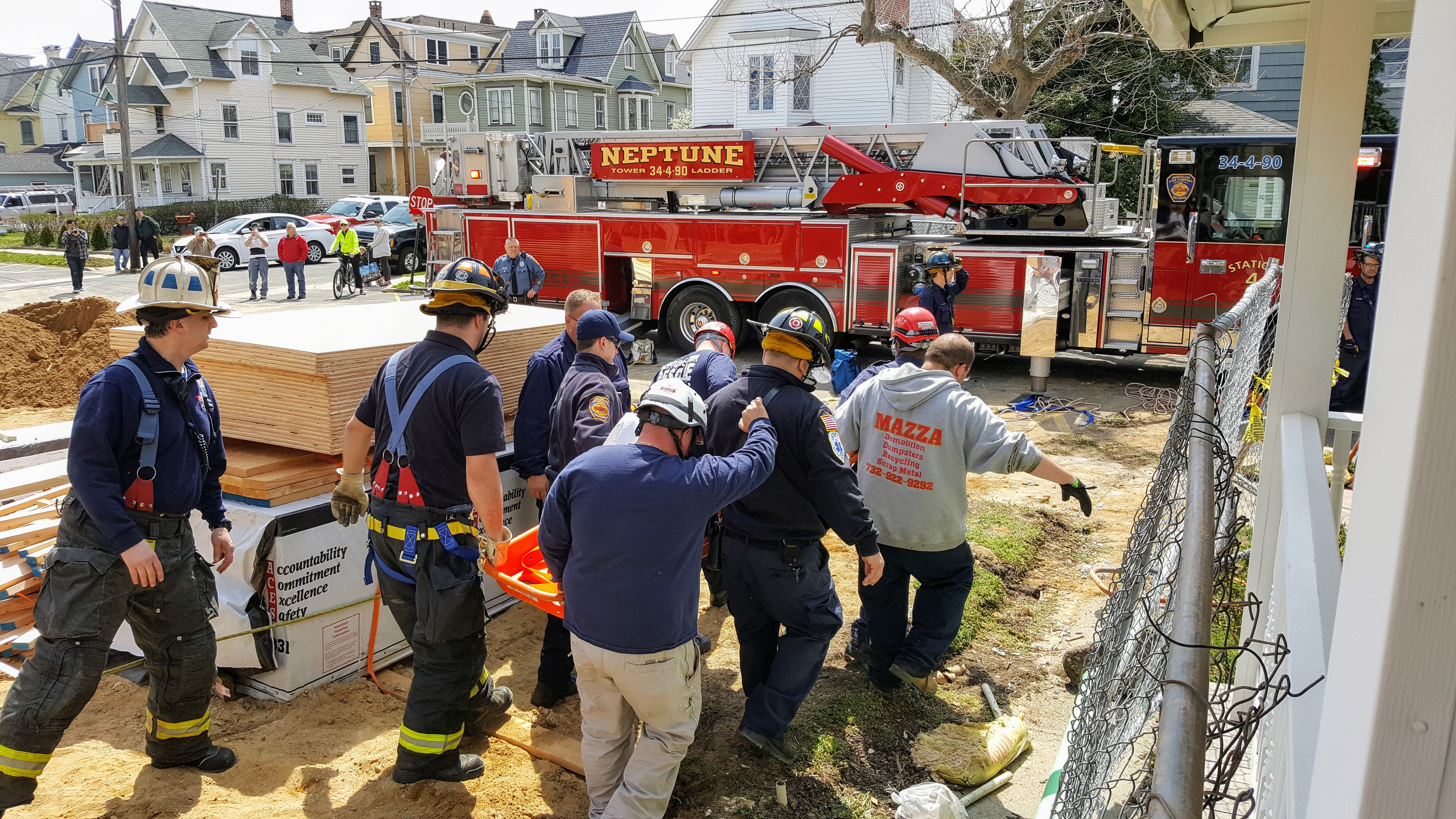
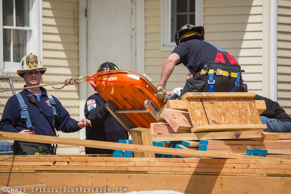
Rescue workers demonstrated some of the work they do when disaster strikes.

“The demo behind this, just demonstrates some of our capabilities as far as establishing a rope rescue system, establishing a high point and then having the capabilities to raise a rescuer and lower a rescuer and ultimately a victim,” said Donald Colarusso, team leader of Neptune Township Special Operations.

During a demo, rescue workers simulated a car accident in which the passengers were unable to get out of the car, which was severely damaged. It required the jaws of life to save them.

“The jaws of life, as they’ve been known since the early 1970s, are hydraulic rescue tools. They are extremely powerful and they help to remove the metal from around the people trapped in the vehicle. These tools have multiple uses and can be used if someone was trapped inside a small space in their house or vehicle floating away and they’re not dependent on electricity. They can run on gasoline power, electric or battery,” said Michael Dileo, deputy emergency management coordinator of Neptune Township Special Operations.

Events like this one aren’t only for residents, first responders can benefit, too.

“You have to be on top of your game, a tragedy can strike at any time, a weather event. We have to be above board and we have to able to respond to any situation. We have to be able to have the equipment to do so,” said Edward Kirschenbaum, director of public safety with the Neptune City Police Department.

During Superstorm Sandy, floodwaters wiped out homes and businesses in this community.

Residents are urged to “know your zone.” It’s a Monmouth County Office of Emergency Management initiative in which all of the coastal communities participate and every home is assigned an evacuation zone based on storm surge projection. The assignments are noted “a” through “d,” with “a” being the most vulnerable. Folks can easily find those zones online.

“It’s good to be informed so you know what to have together and how to have an evacuation plan,” said Lindsay Eppley, Neptune Township resident.

Eppley hopes she doesn’t have to evacuate anytime soon, and still she feels better knowing she’s prepared for the next storm.
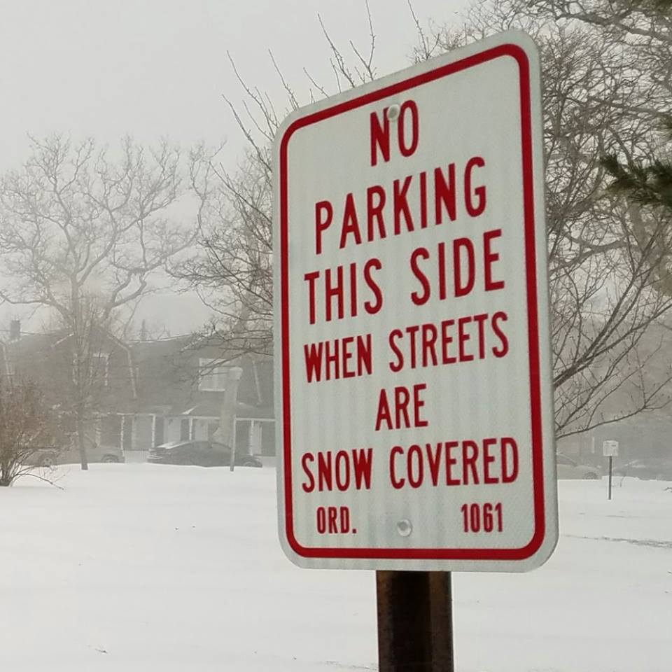
 

Important Information on Rip Currents

Rip Current Safety Information provided by Neptune Township Office of Emergency Management (OEM) and the Area Network of Shore Water Emergency Responders (A.N.S.W.E.R.).

rip_current_PosterAbout Rip Currents

Rip currents are powerful, channeled currents of water flowing away from shore. They typically extend from the shoreline, through the surf zone, and past the line of breaking waves. Rip currents can occur at any beach with breaking waves, including the Great Lakes.

Rip currents can be killers. The United States Lifesaving Association estimates that the annual number of deaths due to rip currents on our nation’s beaches exceeds 100. Rip currents account for over 80% of rescues performed by surf beach lifeguards.

The greatest safety precaution that can be taken is to recognize the danger of rip currents and always remember to swim at beaches with lifeguards. The United States Lifesaving Association has calculated the chance that a person will drown while attending a beach protected by USLA affiliated lifeguards at 1 in 18 million. If caught in a rip current at an unguarded beach, how you respond could make the difference between life and death.

The United States Lifesaving Association, in partnership with NOAA’s National Weather Service and National Sea Grant Program, is working together to raise awareness about the dangers of rip currents. Research is also being conducted inorder to develop and improve the ability to predict the occurrence and strength of rip currents. The goal of the awareness campaign and research is to reduce the number of rip current related fatalities.

With increasing coastal populations, rip currents will continue to be a serious hazard at surf beaches. This web site is designed to provide educational material as well as real time information about the rip current risk. The time you take to understand rip currents can help you protect yourself and your loved ones when visiting the beaches.

Why Rip Currents Form

As waves travel from deep to shallow water, they will break near the shoreline. When waves break strongly in some locations and weakly in others, this can cause circulation cells which are seen as rip currents: narrow, fast-moving belts of water traveling offshore.

Why Rip Currents are Dangerous

Rip currents are the leading surf hazard for all beachgoers. They are particularly dangerous for weak or non-swimmers. Rip current speeds are typically 1-2 feet per second. However, speeds as high as 8 feet per second have been measured–this is faster than an Olympic swimmer can sprint! Thus, rip currents can sweep even the strongest swimmer out to sea.

Over 100 drownings due to rip currents occur every year in the United States.More than 80% of water rescues on surf beaches are due to rip currents.

Rip currents can occur at any surf beach with breaking waves, including the Great Lakes.


https://www.youtube.com/watch?v=LX2o-QpXSso

When Rip Currents Form

Rip currents can be found on many surf beaches every day. Under most tide and sea conditions the speeds are relatively slow. However, under certain wave, tide, and beach profile conditions the speeds can quickly increase to become dangerous to anyone entering the surf. The strength and speed of a rip current will likely increase as wave height and wave period increase. They are most likely to be dangerous during high surf conditions as the wave height and wave period increase.

Where Rip Currents Form

Rip currents most typically form at low spots or breaks in sandbars, and also near structures such as groins, jetties and piers. Rip currents can be very narrow or extend in widths to hundreds of yards. The seaward pull of rip currents varies: sometimes the rip current ends just beyond the line of breaking waves, but sometimes rip currents continue to push hundreds of yards offshore.

How to Identify Rip Currents

Look for any of these clues:

  • a channel of churning, choppy water
  • an area having a notable difference in water color
  • a line of foam, seaweed, or debris moving steadily seaward
  • a break in the incoming wave pattern

None, one, or more of the above clues may indicate the presence of rip currents. Rip currents are often not readily or easily identifiable to the average beachgoer. For your safety, be aware of this major surf zone hazard. Polarized sunglasses make it easier to see the rip current clues provided above.

How to Avoid and Survive Rip Currents

  • Learn how to swim!
  • Never swim alone.
  • Be cautious at all times, especially when swimming at unguarded beaches. If in doubt, don’t go out!
  • Whenever possible, swim at a lifeguard protected beach.
  • Obey all instructions and orders from lifeguards.
  • If caught in a rip current, remain calm to conserve energy and think clearly.
  • Don’t fight the current. Swim out of the current in a direction following the shoreline. When out of the current, swim towards shore.
  • If you are unable to swim out of the rip current, float or calmly tread water. When out of the current, swim towards shore.
  • If you are still unable to reach shore, draw attention to yourself: face the shore, wave your arms, and yell for help.
  • If you see someone in trouble, get help from a lifeguard. If a lifeguard is not available, have someone call 9-1-1 . Throw the rip current victim something that floats and yell instructions on how to escape. Remember, many people drown while trying to save someone else from a rip current.

Rip Current Myth

A rip current is a horizontal current. Rip currents do not pull people under the water–-they pull people away from shore. Drowning deaths occur when people pulled offshore are unable to keep themselves afloat and swim to shore. This may be due to any combination of fear, panic, exhaustion, or lack of swimming skills.

In some regions rip currents are referred to by other, incorrect terms such as rip tides and undertow. We encourage exclusive use of the correct term – rip currents. Use of other terms may confuse people and negatively impact public education efforts.

Source:  NOAA and USLA

##

Confined Space Rescue at Construction Site in Neptune Township

20170413_122408 (1)April 13, 2017

Neptune Township EMS was dispatched to a reported fall victim at a work site at Bath Avenue and Beach Avenue in the Ocean Grove section of Neptune Township.

Upon arrival, EMT’s found a male who had fallen approximately 10-12 feet from a first floor into a basement.  EMT’s accessed the patient along with MONOC paramedics, and also identified that this situation was a confined space incident.

At 11:57 AM, the Neptune Township Special Operations Rescue Team was dispatched.

17903951_1295914130473969_1980350954315254037_nUpon arrival, Special Operations team members assessed with on-scene medical personnel and determined that the patient needed to be stabilized and removed via stokes basket.

As the patient was being packaged in the confined space, rescuers topside set up a rope haul system.  Once the patient was ready, the stokes basket was hauled up to the first floor, the stoke was detached from the rope system and the patient was transported by ambulance to Jersey Shore University Medical Center.

Units that operated at the scene included Neptune Township Emergency Medical Services, Neptune Township Special Operations Rescue Team (Station 34-8), Neptune Township EMS Rescue Services (Squad 34-25) and Neptune Township Police Department.


Photo Credit: Chris Spiegel and Kyle Bascom


##

TS Hermine: Storm Update 9/3/2016 @ 9am

TROPICAL STORM MOVING OFF NORTH CAROLINA COAST THIS MORNING…. WILL STALL IN THE NEARBY COASTAL WATERS ABOUT 100 TO 150 MILES TO OUR SOUTHEAST BRINGING COASTAL FLOODING, GUSTY WINDS, AND RAIN THROUGH EARLY TUESDAY

SEPTEMBER 3RD – 9AMNOAA 0903

Hermine is currently emerging back over water and will move northeast today before stalling east of the Delaware coast about 100 to 150 miles to our southeast with highest sustained winds of 60 mph.  As the storm sits over well above normal water temperatures, it will begin to restrengthen and likely reattain hurricane status.  On Sunday, Hermine will likely drift a bit westward before slowly turning northward on Monday and then northeastward later Monday.  The effects of Hermine will be felt into Tuesday.

The model spread has narrowed quite a bit over the last 24 hours and the forecast track and strength remains the same as yesterday’s forecast.  This will result in tropical storm force winds along the coast from Saturday night through Monday, and possibly Tuesday as well.

Here is a breakdown on the expected impacts from Hermine:

Rainfall – The cloud sheild of Hermine has overspread the area and the associated rainfall is entering extreme southern NJ.  In central NJ, it will likely remain dry most of the day as rain slowly moves into southern NJ.  Sunday and Monday will see bands of rain and squalls moving onshore with higher rainfall totals further south and at the coast.  Additional rain could occur on Tuesday.  Total rainfall amounts in central Jersey/Neptune area are likely to be 1 to 2 inches with more rain, 2 to 4 inches, further south along the coast and less rain north and west of the NJ Turnpike

Wind – Northeast winds will be increasing during the day today.  Along the coast, sustained winds of 30 mph with gusts to 45 mph are likely from Saturday night through Tuesday.  Further inland sustained winds of 20 mph with gusts to 40 mph are likely.  Residents should remove or secure loose outdoor objects as soon as possible.

Seas – Building to 6 to 9 feet this afternoon, 12 to 16 feet Sunday and Monday, 9 to 12 feet on Tuesday.

Coastal flooding – We will be dealing with minor to moderate coastal flooding for 6 successive high tides from tonight through Tuesday morning.  The worst of the tides will be Sunday night around 11pm and Monday morning around 11:30am.  The persistent northeast winds for several days will not allow water to drain from back bays with each successive high tide.  The coastal flooding will be more pronounced in coastal southern NJ from Long Beach Island and points south where major flooding could occur Sunday night and Monday morning.  Tidal departures in Monmouth and northern Ocean County will likely be around 3 feet above normal with the highest tides Sunday and on Labor Day causing significant street flooding in the usual low lying areas as well as significant beach erosion.  From LBI and points south, tidal departures of 4 to 5 feet above normal are possible.  I still think the closest most recent analog is the blizzard this past January, but rather than one flooding high tide, the flooding will occur over multiple high tides.  With the blizzard, there was major coastal flooding in southern NJ, while central NJ saw moderate flooding.

Source:  Tri-State Storm Watch

Monmouth County High Water Mark Initiative

The Township of Neptune, in cooperation with Monmouth County, is proud to be participating in the High Water Mark Initiative.

What is the High Water Mark Initiative?

As part of the National Flood Insurance Program (NFIP), the High Water Mark (HWM) Initiative is a community-based awareness program that increases local communities’ awareness of flood risk and encourages action to mitigate that risk.

As part of the project, communities post HWM signs in prominent places, hold a high-profile launch event to unveil the signs, conduct ongoing education to build local awareness of flood risk, and complete mitigation actions to build community resilience against future flooding.  A variety of audiences such as local officials, emergency management personnel, community leaders as well as FEMA Regions, Federal, state, and local entities can learn more about the HWM Initiative in the sections below.


Monmouth County to Launch High Water Mark Initiative

Published June 23, 2016

MIDDLETOWN, NJ – The Monmouth County Board of Chosen Freeholders and Sheriff Shaun Golden will launch the county’s High Water Mark Initiative with the placement of the first sign at the county’s Belford Ferry Terminal, 10 Harbor Way.

The sign and others like it signify the height of the flood water during Superstorm Sandy. The signs are designed to draw attention to the potential for flooding in communities and acknowledge the location of historic flood events. The program falls under the National Flood Insurance Program

“Fourteen Monmouth County towns have joined the High Water Mark Initiative,” said Freeholder Deputy Director Serena DiMaso. “These towns have made a commitment to improving their resiliency to future storms and in the process reduced flood insurance premiums for their residents.”

Participating towns are: Aberdeen, Atlantic Highlands, Avon, Belmar, Hazlet, Keansburg, Manasquan, Middletown, Monmouth Beach, Neptune Township, Ocean Township, Oceanport, Rumson and Sea Bright.


When Thunder Roars, Go Indoors

thunder_roarsAccording to the National Weather Service (NWS), lightning strikes the United States about 25 million times each year. While lightning mostly occurs during the summer months, it can happen at any time of the year.

Talk with your family about staying safe during thunderstorms. Here are just a few lightning safety tips that the NWS offers if you are indoors:

  • Stay off corded phones. You can use cellular or cordless phones;
  • Don’t touch electrical equipment such as computers, TVs, or cords. You can use the remote control safely; and
  • Stay away from windows and doors that might have small leaks around the sides to let in lightning, and stay off porches.

According to the NWS, if you are outside during a storm it is important to get inside a safe building or vehicle. You are NOT safe outdoors, but if you absolutely cannot get to safety, follow these tips to slightly lessen the threat of being struck by lightning:

  • Avoid open fields, the top of a hill, or a ridge top;
  • Stay away from tall, isolated trees or other tall objects. If you’re in a forest, stay near a lower stand of trees; and

If you’re in a group, spread out to avoid the current traveling between group members.

##


WINTER STORM affecting Neptune Township (01/22/2016)

View the Weather Statement (pdf):  WEATHER STATEMENT – JONAS #1 (002)

TOWNSHIP OF NEPTUNE – Office of Emergency Management
STORM PREPAREDNESS INFORMATION

CURRENT NWS FORECAST:

  • Winter Storm Watch in effect;
  • Snow is forecasted to begin in the southern portion of the state during the evening commute and progressing up the coast impacting Monmouth County starting around midnight on Friday into Saturday.
  • This will be a large snow event with 6-12 inches accumulating.
  • Storm will start with snow, and may change to sleet and/or rain and then change back to snow.
  • Snow will initially be light and puffy, but will change to heavy wet – The change will lessen the blowing and drifting.
  • Wind gusts along the coast will be 50-60 MPH and 40 MPH inland- and will begin around 12 midnight Friday.
  • Storm is slow moving and will end Sunday morning;
  • While there will be moderate to major flooding in some areas, the Neptune Township area is forecasted to be at minor levels;
  • Temperatures will be near or above normal after the storm passes.

TOWNSHIP PREPARATIONS:

  • Main roads, hills and curves will be pre-treated with liquid brine by DPW.
  • All snowplows and salt spreaders are prepared and ready to go.
  • Storm drains continue to be cleared and all refuse will be removed by the end of the workday on Friday.
  • Monitoring all lake levels and flood projections and will lower the lake levels if flooding in excess of street flooding is predicted.
  • Emergency service departments; Police; Fire, EMS & OEM are prepared and ready to respond as needed.
  • Monitoring of weather and storm forecasts will continue throughout the event, with public information provided to our residents via social media, website, and mobile apps.
  • Emergency Operations Center has been readied for activation.

RESIDENT PREPARATIONS:

  • Go to www.Ready.gov or www.NeptuneOEM.com on your computer for preparedness information.
  • Have a good snow shovel and deicer at the ready.
  • Check flashlights and batteries and have extra on hand. Be prepared for power outages.
  • Shovel out fire hydrants located on your property to assist fire department response.
  • Clear storm drains near your property to reduce potential street flooding.
  • Check on the elderly or otherwise dependent neighbors.

To stay updated with the conditions in Neptune, the following options are available to the public:

  • Download the free Neptune Township PD and OEM Mobile Apps, available for iPhone and Android. Search “Neptune Township” in the App/Google Play Stores.
  • Follow the Neptune Township Office of Emergency Management on Twitter @NeptuneOEM.
  • Follow the Neptune Township Police Department on Twitter @NeptunePolice.
  • Like Neptune Township and Neptune Township OEM on Facebook.


##

Neptune Township advises residents to prepare for potential storms

NEPTUNE, N.J.—With Tropical Storm Joaquin having become a hurricane, Neptune Township Emergency Management Coordinator, Michael J. Bascom is advising residents to prepare now for potential weather-related power outages, localized flooding and wind damage this weekend.

“While it is too early to determine what path this storm will take and how it will impact our region, it is not too early to take measures to protect your family and property from the potential impact of Joaquin and the Nor’easter that are currently forecasted to impact our area.,” Bascom said. “Protecting ourselves from potential storm damage is something we have become accustomed to along the Jersey Shore.”

Bascom said people should have an ample supply of food and water at home in case of power outages or travel restrictions. People should limit travel and stay indoors while the storm is active. Coastal flooding is currently projected to cause roadway flooding, but emergency management officials will monitor forecasts closely and take appropriate actions should the flood threat become more significant.

“With the possibility of threatening weather, I urge our residents to follow reports on local radio, TV and the Internet for the latest weather information.” said Mayor Mary Beth Jahn. “If you haven’t already done so, now would be a good time to load the free Neptune OEM “app” on your cellular phone.”

The Township is monitoring the levels of Lake Alberta, Fletcher Lake, and Wesley Lake and plans to lower the lakes to increase their capacity to accept storm water from the street drainage systems. While this helps, it does eliminate the threat of street flooding, thus residents are urged not to park in flood prone areas.

Bascom suggested taking the following readiness steps in preparation for storms:

  • Put together a kit of emergency supplies that includes a three-day supply of canned, non-perishable, ready-to-eat food; a three-day supply of water (a total of 3 gallons per family member); a battery-operated radio and extra batteries; a flashlight and extra batteries; and a first aid kit. Additional information and checkslists can be found at www.ready.gov and www.neptuneoem.com.
  • Make a plan for what you and your family will do during an emergency. This includes knowing how to evacuate and how to “shelter in place,” which means stay home and avoid driving if at all possible.
  • Stay informed of possible threats by tuning in to your local media outlets for the latest breaking weather news.

The State Office of Emergency Management has prepared a “Hurricane Survival Guide for New Jersey” that’s a complete resource for preparing your home or business for hurricane season. You can find it on the New Jersey OEM website, www.ready.nj.gov/.

Release by Neptune Township – September 30, 2015 @ 4:00 PM


##

Neptune OEM offers information on Nor’Easter storms

IMG_9660What is a Nor”Easter?  It is a cyclonic storm that moves along the east coast of North America.  It’s called “nor’easter” because the winds over coastal areas blow from a northeasterly direction.

Nor’easters may occur any time of the year, but are most frequent and strongest between September and April. These storms usually develop between Georgia and New Jersey within 100 miles of the coastline and generally move north or northeastward.

Nor’easters typically become most intense near New England and the Canadian Maritime Provinces. In addition to heavy snow and rain, nor’easters can bring gale force winds greater than 58 miles per hour. These storms can produce rough seas, coastal flooding and beach erosion.

The East Coast of North America provides an ideal breeding ground for nor’easters.  During winter, the polar jet stream transports cold Arctic air southward across the plains of Canada and the U.S., and eastward toward the Atlantic Ocean, as warm air from the Gulf of Mexico and the Atlantic tries to move northward. The warm waters of the Gulf Stream help keep the coastal waters relatively mild during the winter, which in turn helps warm the cold winter air over the water. This difference in temperature between the warm air over the water and cold Arctic air over the land is the area where nor’easters are born.

– Source:  http://www.noaa.gov/features/03_protecting/noreasters.html  

WP2Social Auto Publish Powered By : XYZScripts.com