
TROPICAL STORM MOVING OFF NORTH CAROLINA COAST THIS MORNING…. WILL STALL IN THE NEARBY COASTAL WATERS ABOUT 100 TO 150 MILES TO OUR SOUTHEAST BRINGING COASTAL FLOODING, GUSTY WINDS, AND RAIN THROUGH EARLY TUESDAY
SEPTEMBER 3RD – 9AM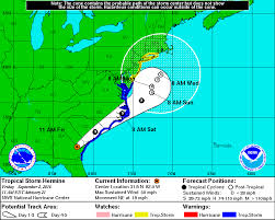
Hermine is currently emerging back over water and will move northeast today before stalling east of the Delaware coast about 100 to 150 miles to our southeast with highest sustained winds of 60 mph. As the storm sits over well above normal water temperatures, it will begin to restrengthen and likely reattain hurricane status. On Sunday, Hermine will likely drift a bit westward before slowly turning northward on Monday and then northeastward later Monday. The effects of Hermine will be felt into Tuesday.
The model spread has narrowed quite a bit over the last 24 hours and the forecast track and strength remains the same as yesterday’s forecast. This will result in tropical storm force winds along the coast from Saturday night through Monday, and possibly Tuesday as well.
Here is a breakdown on the expected impacts from Hermine:
Rainfall – The cloud sheild of Hermine has overspread the area and the associated rainfall is entering extreme southern NJ. In central NJ, it will likely remain dry most of the day as rain slowly moves into southern NJ. Sunday and Monday will see bands of rain and squalls moving onshore with higher rainfall totals further south and at the coast. Additional rain could occur on Tuesday. Total rainfall amounts in central Jersey/Neptune area are likely to be 1 to 2 inches with more rain, 2 to 4 inches, further south along the coast and less rain north and west of the NJ Turnpike
Wind – Northeast winds will be increasing during the day today. Along the coast, sustained winds of 30 mph with gusts to 45 mph are likely from Saturday night through Tuesday. Further inland sustained winds of 20 mph with gusts to 40 mph are likely. Residents should remove or secure loose outdoor objects as soon as possible.
Seas – Building to 6 to 9 feet this afternoon, 12 to 16 feet Sunday and Monday, 9 to 12 feet on Tuesday.
Coastal flooding – We will be dealing with minor to moderate coastal flooding for 6 successive high tides from tonight through Tuesday morning. The worst of the tides will be Sunday night around 11pm and Monday morning around 11:30am. The persistent northeast winds for several days will not allow water to drain from back bays with each successive high tide. The coastal flooding will be more pronounced in coastal southern NJ from Long Beach Island and points south where major flooding could occur Sunday night and Monday morning. Tidal departures in Monmouth and northern Ocean County will likely be around 3 feet above normal with the highest tides Sunday and on Labor Day causing significant street flooding in the usual low lying areas as well as significant beach erosion. From LBI and points south, tidal departures of 4 to 5 feet above normal are possible. I still think the closest most recent analog is the blizzard this past January, but rather than one flooding high tide, the flooding will occur over multiple high tides. With the blizzard, there was major coastal flooding in southern NJ, while central NJ saw moderate flooding.
Source: Tri-State Storm Watch